For this lab the grand purpose was to give us the tools and resources necessary to conduct distance bearing navigation at the priory for the next upcoming lab, and there were several concepts to be learned and maps to be made in order to properly do so. A few of the concepts we had to familiarize ourselves with included proper use and dissemination of coordinates systems (be it State Plane or UTM), how to accurately measure our pace count, and how to construct a field ready map for use in distance bearing navigation with a compass. Each component of the preparation for an actual field outing can be weighted heavily because if even one element is either not accurate or unusable then the entirety of the process can fail. For example if the pace count is off then any distances measured in the field will be faulty, or if the map grid lines or topology is shifted then the whole of the operation would be offset. By the end of this lab we were prepared with the knowledge and maps needed to conduct the following lab 6 at The Priory.
Methods
Once we had acquainted ourselves with the groups of three we would be in for lab 6 we headed out to the edge of the Phillips parking lot and measured out 100 meters along the sidewalk going towards the Davies center. We then counted the number of steps it took to walk to the 100 meter mark and then divided that number by two (or simply only counted the steps taken by our right foot) which could then be used as a reference to determine distances in the field. For me it would be 58 steps on my right foot for every 100 meters traveled, which I could later use to calculate the number of paces between points in the navigational course at the Priory.
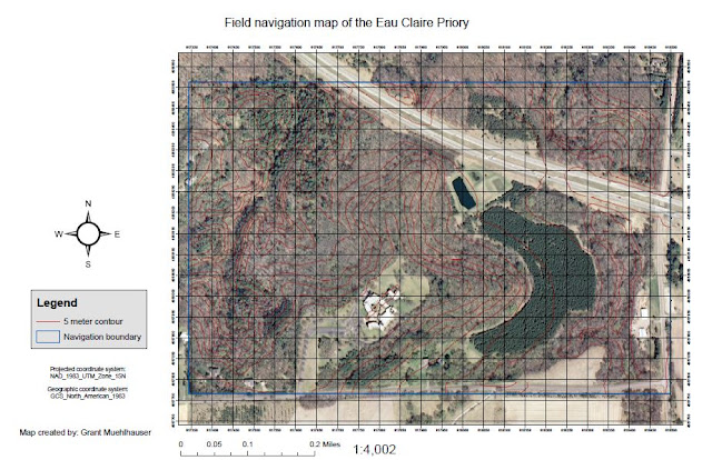
Next was the larger portion of the lab where we would construct two maps of the extent of The Priory navigational course by utilizing data given to us by our professor which included a box outlining the priory's extent, a base map, and the topographic contour intervals (5 meter or 2 foot) for the terrain. The first of the maps was to have an overlayed UTM grid system of 50 meter spacing, which I applied the 5 meter contour lines layer to as a reference for the terrain elevation as we would be navigating the course. The Second map was created using a Geographic Coordinates grid which would display the grid distances in decimal degrees. Either of these maps could be used for the upcoming Lab 6 based on what type of coordinates are supplied to us.
Results
 |
| Figure 1: UTM grid system |
 |
| Figure 2: Geographic coordinates grid system |
Discussion
In regards to coordinate systems used, the geographic coordinate system for each of the maps is GCS_North_American_1983 due to it being what was supplied to us in the basemap which should be used as a coordinate system reference for the rest of the data overlayed. However, the projected coordinate systems for the two different maps differs due to the necessity of having two different grid systems, one being based on the UTM at 50 meter spacing and the other a geographic coordinates system utilizing decimal degree measurements.
For each map the GCS_North_American_1983 ensures higher localized accuracy in North America as opposed to a world wide GCS. For the first map in figure 1, the NAD 1983 UTM zone 15 N projection is the North American Datum Universal Transverse Mercator in zone 15 in the northern hemisphere which utilizes a two dimensional Cartesian coordinate system to pinpoint locations on the Earth's surface. This system divides the Earth into sixty zones each being six degrees in longitude across. It was developed by the US Army Corps of Engineers in the 1940s and was based upon an ellipsoidal model of the Earth. For this lab our study area at the Priory lies within the 15th zone that bisects Wisconsin just left of the dividing line. For the second map in figure 2 the NAD83_Wisconsin_Transverse_Mercator projection is designed as a single zone for the whole state and has an accuracy of less than 1 meter. This projection is based off the Transverse Mercator projection but is localized to Wisconsin for higher accuracy.
No comments:
Post a Comment